LiDAR-fused cellular geolocation for last-known-position estimation in wilderness search-and-rescue
When someone goes missing in rough country, their phone is often the only beacon they carry — but the network can only place it within a vague area kilometres wide. We read the last faint traces of that signal against the shape of the land (from LiDAR) to point searchers at the likeliest ground first, as a ranked map — and we bring mobile towers to where the fixed network can't reach.
A running example — the missing bushwalker
On a Saturday afternoon a bushwalker sets out alone on a ridge track. His phone last had a clear signal at the trailhead car park, sitting on the ridge-top tower with good line-of-sight. Hours later he is overdue. By then his phone — still on, in his pocket, never in a call — has only "checked in" with the network a handful of times as he moved, and the last check-in came from deep in a forested side-gully where the signal went weak and patchy before dropping out.
The network can say, roughly, "somewhere this tower can hear" — an area many kilometres across. Searchers need better than that, fast. We return to this walker throughout.
Why a phone's location is so rough in the bush
Time is the dominant factor in whether a missing person is found alive. Narrowing the search area early concentrates limited searchers and shortens the time to find someone. The phone is usually the only remote clue — but its built-in location estimate is coarse, for three reasons.
- Coverage follows the land, not a neat circle. Hills, gorges, trees, buildings and even bodies of water bend, block and reflect the signal; rain and weather weaken it further. The same signal reading can mean very different places depending on what sits between the phone and the tower.
- Which tower & sector is serving carries information. A tower is split into directional "sectors"; which one a phone uses already narrows the bearing, and the sequence of changes over time hints at movement — even from a single tower.
- In the wilderness, the usual trick fails. The textbook method crosses three or more towers to pin a location. In remote country the phone often reaches only one tower, or none — so that method is unavailable exactly where it's needed most.
The land itself is the missing piece — and we can now measure it
Australia's national ELVIS / Geoscience Australia program provides detailed elevation data — a complete ~30 m model nationwide, plus extensive (though not yet national) high-resolution LiDAR that captures terrain, canopy and structures in 3-D. Feed that into a terrain-aware radio model and invert it: instead of asking "what coverage does this tower give?", ask "given this faint, terrain-distorted signal, where could the phone plausibly have been?" The answer is not a point but a probability corridor — a band along the likely path that tightens where we're confident and widens where we're not.
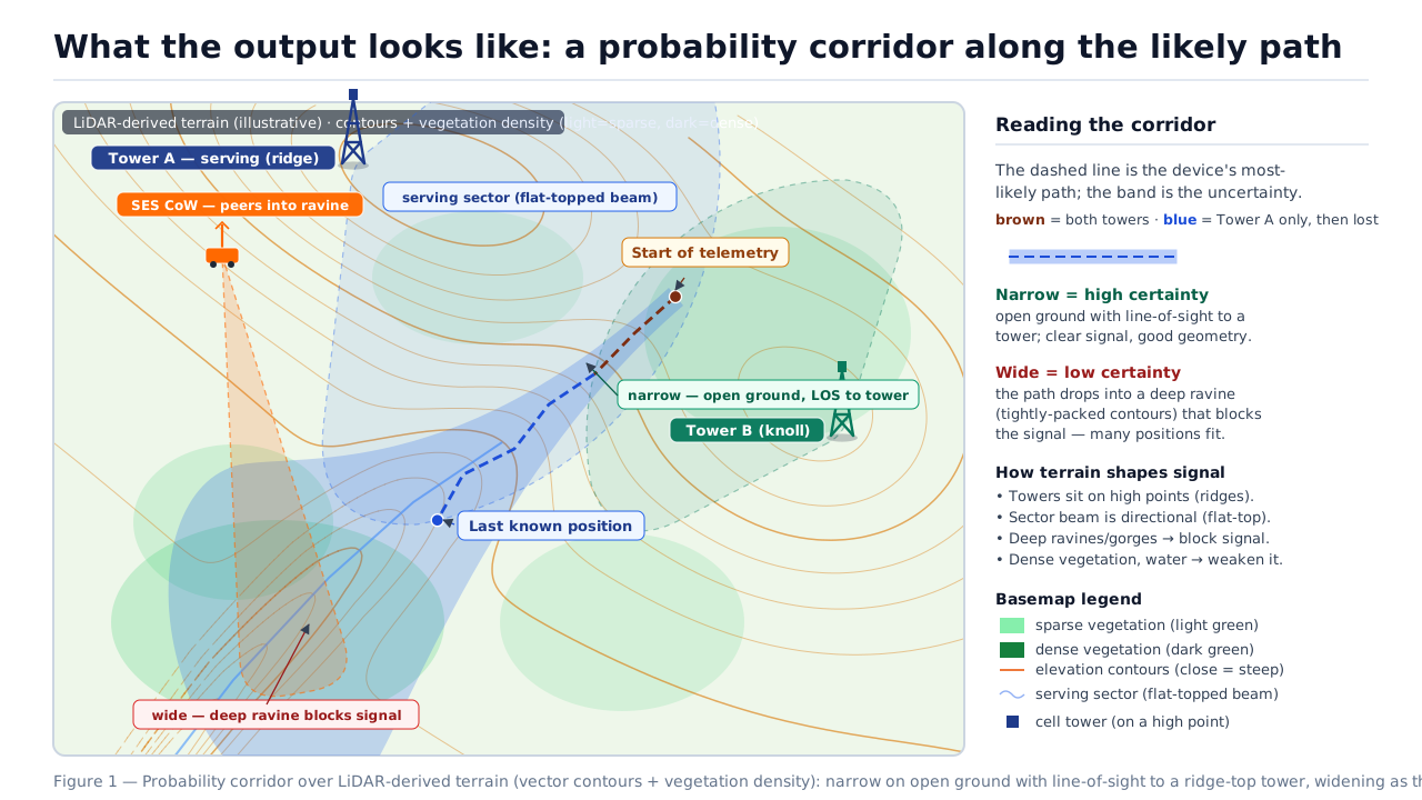
Figure 1 — The intended output, over real LiDAR terrain. The band is narrow where the signal is clear (open ground, line-of-sight to a tower) and balloons where the path drops into a deep ravine — tightly-packed contours (the "Rule of V's": the apex points uphill, with the drainage through it) — that blocks the signal. For the bushwalker: tight along the ridge near the trailhead tower, wide in the forested gully — so search the gully mouth and its drainage first.
What we'll build
Develop and validate a method that fuses cellular data with LiDAR terrain to produce a ranked, probabilistic search area for a missing phone — and characterise mobile-tower techniques that extend reach where the fixed network fails. Six objectives (O1–O6) map to a classified set of research questions.
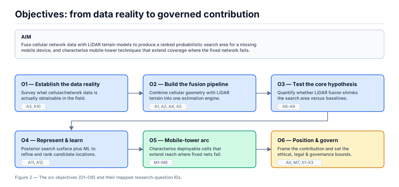
Figure 2 — The six objectives and their mapped research questions.
From a faint signal to a ranked map
We build a terrain-, vegetation-, water- and weather-aware propagation model on the LiDAR surface, then invert it as a Bayesian problem: across a grid of candidate locations, score how well each would reproduce the observed signals, and output a ranked probability surface. Because the pings are time-stamped, we don't judge each one alone — we match the whole sequence to a connected, terrain-walkable path (a motion model over a reachability graph), which links sparse pings into a coherent track. The same LiDAR surface does double duty: it shapes each ping's likelihood and constrains the path.
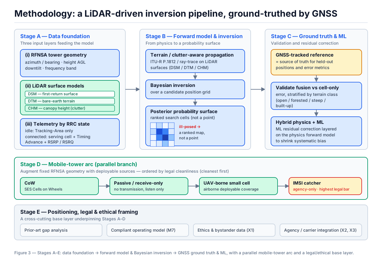
Figure 3 — Stages A–E: data foundation → forward model & inversion → GNSS ground truth & machine learning, with a parallel mobile-tower arc on a legal/ethical base.
Ground truth makes it learnable. Field trials carry GNSS-tracked devices, so every signal-plus-terrain sample is automatically labelled with the true position. That cheap, abundant labelling lets a machine-learning layer learn a correction on top of the physics model — and it is collected with a phone app, so it needs no carrier data to begin.
Starting without carrier data — then earning access to it
The richest input — carrier-held network records — is also the hardest to get: it's tightly regulated by the interception, privacy, telecommunications and data-retention laws, and is realistically released only after the fact under lawful/emergency provisions. So the strategy is sequenced: prove the concept on legally clean data first, then turn results into leverage to unlock carrier data.
Carrier-independent proof of concept
Validate the whole method with no carrier data, from three barrier-free inputs: a phone app that logs the equivalent signal measurements time-synced with GNSS truth (consented, own-device); synthetic data from the propagation model over the LiDAR surface; and public authoritative data (RFNSA tower geometry, ELVIS LiDAR).
Convert results into access
A funded, ethics-cleared project with a working method and real results — paired with a SAR-agency partner (SES/police) — is a far stronger applicant for carrier data than a paper proposal, and reframes the request as emergency-services support, not commercial data mining.
Validate & deploy with real data
Carrier records become a validation-and-enhancement input, not a prerequisite — the method already works without them — and the tool is integrated into SES/police/SAR workflows.
Who holds the data: the carriers (Telstra, Optus, TPG/Vodafone) own the telemetry; tower companies own only the steel, and resellers (MVNOs) hold no raw radio data. There is no central repository to approach.
Each ingredient exists — the combination doesn't
Terrain-aware radio modelling, LiDAR-derived signal attenuation, cellular fingerprinting, and expressing a search target as a probability surface are all established. The contribution is their specific inversion and regime: inverting a high-resolution-LiDAR model to a search-actionable probability corridor from a single serving tower (or none) — the sparse-network wilderness case where the usual triangulation simply isn't available — grounded in Australian data, with a carrier-independent capture path and a GNSS-truthed machine-learning layer.
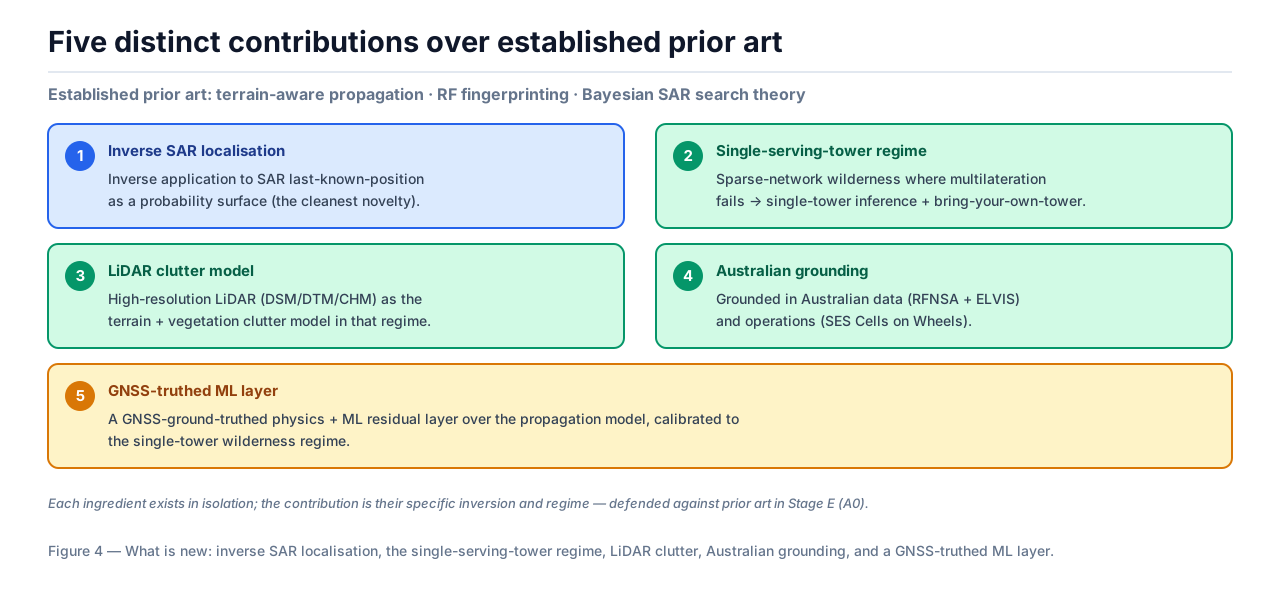
Figure 4 — Five distinct contributions over established prior art.
Closest parallel work. A UTS–TPG research lab is turning mobile-network signals into flood sensors — reading rainfall, water levels and river flows from how phone signals propagate, then feeding a live digital twin for emergency services. It's the same core idea (a signal carries information about the world it travelled through) but the inverse of ours: they read the environment from the signal, while we read the phone's position from the signal using terrain we already know (LiDAR). Encouragingly, their programme runs on a carrier (TPG) and NSW SES partnership — the very access-and-deployment model this project assumes.
When the fixed network can't see the phone: bring a tower to it
A second arc uses mobile cell sites, staged to match what SAR teams already field:
- Confirm (vehicle) — Cells on Wheels. CoWs already exist in the NSW SES vehicle range; drive one to the perimeter to re-establish coverage and confirm the phone is in the catchment.
- Localise & reach (on foot) — a backpack-portable unit. SAR teams already carry packs, so a backpack cell site is the natural next step — carried into gorges and dense bush a vehicle can't reach. Unlike the CoW, a suitable unit is not off-the-shelf and may require construction (integrating radio payload, battery, antenna and backhaul into a rugged pack), so we treat it as a build work-item with its own cost, weight/power budget and — critically — licensing path. This is the unit a ground team carries down into the bushwalker's side-gully once a CoW has confirmed he's in the catchment.
- Aerial reach — a drone-borne unit for fast multi-vantage coverage and lowering toward inaccessible spots.
Legality matters and is kept distinct from the operational order: a carrier-operated portable small cell on licensed spectrum is lawful via partnership, whereas an active "IMSI catcher" (cell-site simulator) is agency-only. The project prefers the legally cleanest options — receive-only detection and carrier/agency-operated cells.
Smaller search areas, faster finds
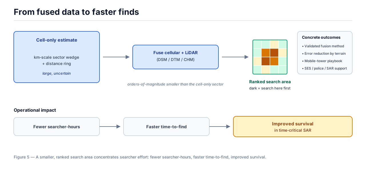
Figure 5 — A smaller, ranked search area concentrates effort: fewer searcher-hours → faster time-to-find → improved survival.
- A validated fusion method and open methodology for ranked search areas from cellular + LiDAR data.
- Quantified error reduction versus cell-only positioning, by terrain class.
- A legally-framed mobile-tower playbook for extending reach.
Every risk has a designed mitigation
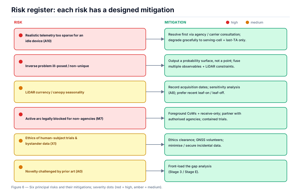
Figure 6 — Six principal risks and their mitigations.
| Risk | How we reduce it |
|---|---|
| Carrier telemetry is legally hard to obtain | Phone-app + public + synthetic data prove the concept first; carrier data becomes later validation (the phased strategy). |
| Idle-phone data is sparse | Degrade gracefully to last serving-cell + timing; link sparse pings with the sequence-to-path motion model. |
| The inverse problem is ambiguous | Output a probability surface, not a point; fuse many cues + LiDAR + the terrain motion prior. |
| Active mobile-tower arc is legally restricted | Foreground Cells on Wheels + receive-only; partner with authorised agencies. |
| Ethics of human-subject & bystander data | Ethics clearance, GNSS volunteers, data minimisation up front. |
Indicative phases and the go / no-go gates
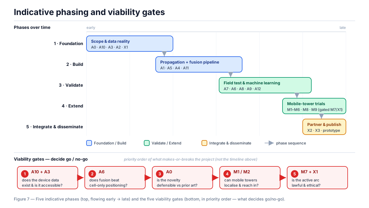
Figure 7 — Five phases (top, early → late) and the five viability gates (bottom, in priority order — what decides go/no-go).
Research in progress — seeking a sponsor & approvals
This is a research proposal, not a finished tool. It stays grounded in real terrain and the last-seen evidence, ranked transparently, with a human coordinator in command: the tool points at likely ground, people decide. Cell-tower data is tightly regulated — only certain authorities and emergency services, under the right circumstances, may access it — so we're seeking both a sponsor and the approvals needed to do the work lawfully and in the right hands.